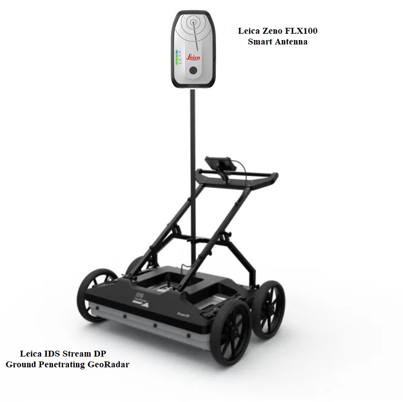
Leica IDS Stream DP GeoRadar
Advanced 3D Ground Penetrating Radar (GPR) System
Overview
The Leica IDS Stream DP is a next-generation multi-channel ground penetrating radar (GPR) system engineered for real-time 3D mapping of underground utilities and subsurface structures. Designed for high-performance surveying, it delivers unmatched depth penetration, resolution, and productivity using advanced radar array technology.
Built on IDS GeoRadar innovation and Leica Geosystems integration, the Stream DP redefines subsurface investigation with true 3D imaging in a single pass, making it ideal for infrastructure, construction, and utility mapping applications.
Key Features
True 3D Subsurface Mapping
- Multi-channel radar array enables real-time 3D visualization
- Eliminates need for multiple scan passes
- Provides accurate underground utility reconstruction
Equalized Scrambled Technology (EsT)
- Proprietary IDS technology for enhanced signal control
- Simultaneous capture of low and high frequencies
- Delivers maximum depth range without sacrificing resolution
High Productivity & Speed
- Large antenna array (multi-channel, dual polarization)
- Covers wide survey areas quickly
- Single-pass data acquisition significantly reduces field time
AI-Powered Data Processing
- AiMaps 2.0 for automated interpretation
- Cloud-based processing and visualization tools
- Faster, smarter decision-making workflows
Compact & Portable Design
- Lightweight modular system (<20 kg per component)
- Fits in standard vehicles (approx. 116 × 82 cm footprint)
- Deployable by one operator in under 5 minutes
Continuous Operation
- Low power consumption (~15–19W)
- Hot-swappable batteries for uninterrupted surveys
Terrain Versatility
- Configurable for:
- Asphalt (pivoting wheels)
- Rugged terrain (off-road wheels)
- Suitable for urban and harsh environments
Technical Specifications
| Specification | Details |
|---|---|
| System Type | Multichannel GPR array |
| Channels | Up to 30 channels (19 VV + 11 HH dual polarization) |
| Technology | Equalized Scrambled Technology (EsT) |
| Imaging | Real-time 3D subsurface mapping |
| Depth Capability | Extended depth range (industry-leading performance) |
| Resolution | Ultra-high resolution (multi-frequency capture) |
| Positioning | GPS integration with Pulse-Per-Second (PPS) synchronization |
| Power Consumption | Approx. 15–19W |
| Weight | ≤ 20 kg per module |
| Dimensions | Approx. 116 × 82 cm |
| Operation | Single-operator deployment |
| Software | uMap (field), IQMaps & AiMaps (processing) |
Note: Depth and performance depend on soil conditions and environment.
Software Ecosystem
uMap (Field Software)
- Real-time data acquisition
- User-friendly interface for field crews
IQMaps (Post-Processing)
- Advanced data analysis tools
- Cloud-enabled workflow integration
AiMaps 2.0
- AI-assisted interpretation
- Enhanced visualization of underground utilities
- Faster reporting and decision-making
Applications
The Stream DP is ideal for:
- Utility detection and mapping
- Infrastructure and construction planning
- Road and pavement analysis
- Urban development surveys
- Archaeological investigations
- Environmental and geotechnical studies
Benefits
- ✅ Maximum depth + resolution (no trade-off)
- ✅ True 3D results in a single scan
- ✅ Reduced field time and labor costs
- ✅ AI-enhanced data interpretation
- ✅ Highly portable and easy to deploy
- ✅ Scalable for multiple terrain conditions
Why Choose Leica IDS Stream DP?
The Stream DP stands out as one of the most advanced GPR systems available, combining multi-channel radar technology, AI-driven analytics, and unmatched depth performance to deliver superior results in complex subsurface environments.
It is designed for professionals who require:
- High accuracy
- Fast data acquisition
- Reliable performance in demanding conditions
Call to Action (+1-808-210-8303)
Request a demo or quote today to see how the Leica IDS Stream DP can transform your underground mapping capabilities.