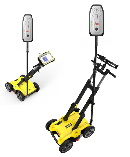
Leica DSX Utility Detection Solution
Intelligent Ground Penetrating Radar for Utility Detection & Mapping
Overview
The Leica DSX Utility Detection Solution is an advanced, fully integrated ground penetrating radar (GPR) system designed to simplify and accelerate underground utility detection. Developed by Leica Geosystems, the DSX combines intuitive hardware with powerful software automation to deliver real-time 2D and 3D utility mapping directly in the field.
Unlike traditional GPR systems, the DSX is engineered for ease of use, enabling both experienced professionals and new users to detect, visualize, and map subsurface utilities with minimal training.
Key Features
Simple & Intuitive Operation
- Guided workflows enable fast setup and operation
- Designed for users with minimal GPR experience
- Perform complete utility detection in just a few steps
Real-Time 2D & 3D Mapping
- Generates instant utility maps on-site
- Visualize underground infrastructure in real time
- Export results to CAD, BIM, and GIS platforms
Automated Data Interpretation
- Built-in algorithms automatically process radar data
- Reduces need for manual interpretation
- Improves accuracy and efficiency in the field
High Productivity Workflow
- Complete scan → process → map workflow in one system
- Real-time processing eliminates long post-processing times
- Quick Scan mode for rapid site assessment
Integrated Software Ecosystem (DXplore)
- Centralized platform for:
- Data acquisition
- Processing and interpretation
- Reporting and export
- Cloud compatibility for sharing and collaboration
Positioning Integration
- Compatible with GNSS and total stations
- Produces survey-grade georeferenced utility maps
- Seamless integration with construction and GIS workflows
Complete Detection Workflow
- Supports full lifecycle:
- Data collection
- Utility detection
- Mapping and reporting
- Excavation planning
- Enhances safety and reduces risk of utility strikes
Technical Specifications
| Specification | Details |
|---|---|
| System Type | Ground Penetrating Radar (GPR) Utility Detection Solution |
| Central Frequency | ~600 MHz |
| Detection Depth | Up to ~2.0–2.4 m (6.5–7.8 ft) |
| Acquisition Speed | Up to 7 km/h (4.3 mph) |
| Scan Interval | 0.50 m (grid scan) |
| Positioning | Wheel encoders; optional GNSS integration |
| Data Output | 2D & 3D utility maps |
| Software | DXplore (data acquisition, processing, reporting) |
| Environmental Rating | IP65 |
| Operating Temperature | -10°C to +40°C |
| Weight | ~23 kg (without battery/tablet) |
| Battery | Li-ion (up to ~8 hours operation) |
| Connectivity | WiFi, Bluetooth, 4G LTE (tablet) |
Specifications may vary depending on configuration and environmental conditions.
Software & Workflow
DXplore Software Platform
- Automated interpretation and visualization
- Real-time grid guidance and data capture
- Integration with utility records and GIS data
Field-to-Finish Workflow
- Import existing utility records
- Scan and detect underground features
- Automatically generate 3D utility maps
- Export data for design, planning, or excavation
Applications
The Leica DSX is ideal for:
- Utility locating and mapping
- Subsurface Utility Engineering (SUE)
- Construction and excavation planning
- Road and infrastructure maintenance
- Municipal and utility asset management
Benefits
- ✅ No GPR expertise required
- ✅ Real-time 2D & 3D visualization
- ✅ Automated data processing and interpretation
- ✅ Survey-grade accuracy with GNSS integration
- ✅ Reduced project time and costs
- ✅ Improved safety and utility strike prevention
Why Choose Leica DSX?
The Leica DSX stands out as one of the most user-friendly and efficient utility detection systems available, combining automation, real-time mapping, and survey-grade accuracy into a single platform.
It is ideal for organizations looking to:
- Increase productivity
- Reduce reliance on highly specialized operators
- Deliver fast, accurate subsurface data
Call to Action (+1-808-210-8303)
Request a demo or quote today to see how the Leica DSX Utility Detection Solution can streamline your utility detection and mapping workflow.