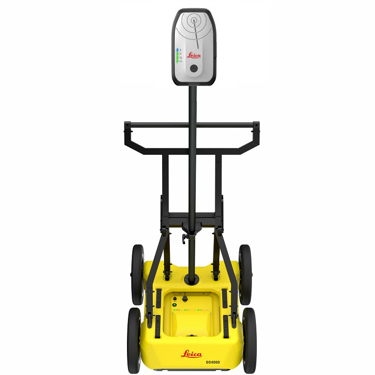
Leica DS4000 Utility Detection System
Advanced Ground Penetrating Radar (GPR) for Subsurface Utility Mapping
Overview
The Leica DS4000 Utility Detection Radar is a high-performance dual-antenna ground penetrating radar (GPR) system designed to deliver accurate, deep, and reliable underground utility detection.
Engineered by Leica Geosystems, the DS4000 integrates advanced radar technology to detect both shallow and deep subsurface features—including difficult-to-locate assets like fiber optic cables—helping reduce risk before excavation.
With its extended depth range, real-time visualization, and streamlined workflow, the DS4000 is ideal for utility locating professionals, engineers, and construction teams.
Key Features
Extended Depth Detection
- Detects underground utilities up to 60% deeper than traditional GPR systems
- Identifies both shallow and deep buried objects
- Detects non-metallic utilities such as fiber optics
Dual-Antenna Technology
- Equipped with 200 MHz and 900 MHz antennas
- Covers a wide frequency range (80–1500 MHz) for maximum versatility
- Balances depth penetration and high-resolution imaging
Equalized Scrambled Technology (EsT)
- Proprietary IDS technology for enhanced signal clarity
- Improves detection accuracy in complex environments
- Delivers both deep penetration and high-resolution data simultaneously
Fast & Efficient Field Operation
- Quick Scan Mode for rapid data acquisition
- Real-time visualization and on-site marking
- Single-operator deployment with compact design
Advanced Software Integration
- uMap (Field Software):
- Real-time data capture and visualization
- Automatic calibration and reporting
- IQMaps (Processing Software):
- Advanced 3D data processing
- Export to CAD and GIS platforms
Portable & Rugged Design
- Lightweight system (~20 kg / 44 lbs)
- Foldable and compact for transport
- IP65-rated for harsh environments
Continuous Operation
- Hot-swappable battery system
- Up to 8 hours operation with dual batteries
- Low power consumption (~16W active)
Technical Specifications
| Specification | Details |
|---|---|
| System Type | Dual-antenna GPR system |
| Channels | 2 |
| Antenna Frequencies | 200 MHz & 900 MHz |
| Frequency Range | 80–1500 MHz |
| Technology | Equalized Scrambled Technology (EsT) |
| Detection Depth | Up to 60% deeper than traditional systems |
| Polarization | HH and VV |
| Dimensions (Operating) | 750 × 625 × 1000 mm |
| Dimensions (Transport) | 750 × 625 × 420 mm |
| Weight | 20 kg (44 lbs) |
| Operating Temperature | -20°C to +50°C |
| Environmental Rating | IP65 |
| Positioning | Encoder, external GPS/GNSS, Total Station |
| Power Consumption | 16W (active), 12W (standby) |
| Battery Life | 4 hrs (1 battery), up to 8 hrs (2 batteries) |
| Wheels | 310 mm standard / 380 mm optional |
Performance may vary depending on soil conditions and environment.
Applications
The Leica DS4000 is ideal for:
- Utility locating and mapping
- Subsurface utility engineering (SUE)
- Construction and excavation planning
- Infrastructure and roadwork projects
- Urban and high-density utility environments
Benefits
- ✅ Detect deeper and more accurately
- ✅ Reduce excavation risk and costly damages
- ✅ Identify both metallic and non-metallic utilities
- ✅ Streamline workflows with real-time data
- ✅ Improve safety and compliance
Why Choose Leica DS4000?
The DS4000 stands out as a next-generation utility detection system, combining dual-frequency radar, advanced signal processing, and real-time software integration to deliver unmatched performance in the field.
It is the ideal solution for professionals who demand:
- High accuracy
- Deep detection capability
- Efficient field operations
- Reliable data for critical decisions
Call to Action (+1-808-210-8303)
Request a demo or quote today to see how the Leica DS4000 can enhance your utility detection and subsurface mapping capabilities.