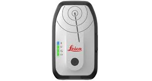
Leica DT100 FLX100 Plus
Smart GNSS Antenna for High-Accuracy GIS Data Collection
Overview
The Leica Zeno FLX100 plus is a compact, high-performance GNSS smart antenna designed for accurate, flexible, and efficient GIS data collection. Built by Leica Geosystems, it delivers centimeter-level accuracy, seamless mobile connectivity, and advanced tilt compensation—making it ideal for professionals in utilities, mapping, and infrastructure.
With its bring-your-own-device (BYOD) approach, the FLX100 plus pairs easily with smartphones and tablets, enabling fast deployment and streamlined workflows in the field.
Key Features
Centimeter-Level Accuracy
- Achieves ~2 cm positioning accuracy
- Suitable for high-precision GIS and asset mapping
- Supports RTK workflows for enhanced accuracy
Tilt Compensation Technology
- Measure accurately even when the pole is tilted
- Works efficiently in hard-to-reach or obstructed locations
- Maintains accuracy even at angles (up to ~30° tilt)
Bring Your Own Device (BYOD)
- Compatible with:
- iOS
- Android
- Windows devices
- Connects via Bluetooth to smartphones or tablets
- Flexible integration with preferred data collection apps
Flexible Software Ecosystem
- Works with:
- Leica Zeno Mobile One
- Leica Zeno Connect
- Third-party GIS apps (e.g., ArcGIS)
- Enables real-time data capture and cloud integration
Compact & Lightweight Design
- Palm-sized GNSS receiver
- Easy to carry and deploy in the field
- Can be used:
- Handheld
- Mounted on a survey pole
Rugged & Jobsite Ready
- IP67-rated (dustproof and waterproof)
- Built for harsh environments
- Reliable performance in challenging conditions
Long Battery Life
- Designed for extended field operations
- Supports full-day data collection workflows
Technical Specifications
| Specification | Details |
|---|---|
| Device Type | GNSS Smart Antenna |
| Positioning Accuracy | ~2 cm (RTK) |
| Tilt Compensation | Yes (accurate up to ~30° tilt) |
| Connectivity | Bluetooth |
| Device Compatibility | iOS, Android, Windows |
| Software Support | Zeno Mobile One, Zeno Connect, third-party GIS apps |
| Operation Modes | Handheld or pole-mounted |
| Environmental Rating | IP67 (dustproof & waterproof) |
| Form Factor | Compact, lightweight (palm-sized) |
| Power | Internal battery (full-day operation) |
Note: Accuracy depends on GNSS correction services and environmental conditions.
Software Ecosystem
Leica Zeno Mobile One
- Intuitive field data collection app
- Simplifies GIS workflows
- Compatible with ArcGIS platforms
Leica Zeno Connect
- Enables integration with third-party apps
- Provides flexibility across workflows
HxGN SmartNet
- Global GNSS correction service
- Enhances accuracy and reliability
Applications
The Leica Zeno FLX100 plus is ideal for:
- Utility mapping and asset management
- GIS data collection and surveying
- Infrastructure inspection
- Environmental and land management
- Municipal and smart city mapping
Benefits
- ✅ High accuracy without complex setup
- ✅ Flexible device compatibility (BYOD)
- ✅ Faster data capture with tilt compensation
- ✅ Compact and highly portable
- ✅ Works with industry-standard GIS software
- ✅ Reliable in tough field conditions
Why Choose Leica FLX100 plus?
The FLX100 plus delivers a powerful combination of accuracy, flexibility, and ease of use, making it one of the most accessible professional GNSS solutions available. Its ability to pair with everyday smart devices while maintaining survey-grade precision makes it ideal for organizations seeking efficiency without sacrificing performance.
Call to Action (+1-808-210-8303)
Request a demo or quote today to see how the Leica Zeno FLX100 plus can streamline your GIS data collection workflow.